
No products
This item added to your cart. Calculate any delivery cost at next step.
There are 0 items in your cart. There is 1 item in your cart.
The Scottsdale area is blessed with many great wilderness preserves nearby, including some located right inside the incorporated cities within Maricopa County. All feature hiking trails to suit all fitness levels - from relatively flat strolls for casual hikes to trails guaranteed to give even the strongest a good workout.
Visitors from out of town, and even some locals, frequently ask our store staff about a few good places to go hiking, so we've put together our top 10 suggestions for good hikes that are all a short drive from central Phoenix. Some of our favorites are the trails you can hike in and around the Lost Dog Wash area:
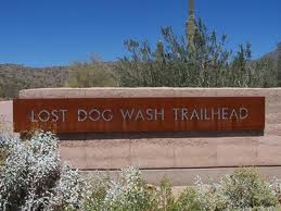
The Lost Dog Wash Access Area, located at the north end of 124th Street just beyond Anasazi Elementary School, is one of the major access points for the Preserve. This award-winning trailhead provides extensive vehicle and equestrian parking along with a gathering area and other amenities.
12601 N 124th St
Scottsdale, AZ 85259
https://www.mcdowellsonoran.org/trailhead/displayLocation/5#sthash.ZJx0nIZ9.dpuf
Access this trailhead from via Linda or Shea Blvd in east Scottsdale and head north on 124th street, which will dead-end at the trailhead.
There are restrooms, cooled water, and a large area map at the trailhead facility. Some of the trails you can access from the trailhead include:
Sunrise Trail East (from Sunrise Trailhead)
Description: Challenging out-and-back hike with many steep sections; rocky in places
Noteworthy Features: Sunrise Peak is one of very few Preserve peaks with a trail to the top, from which there are expansive views in all directions; beautiful granite formations; lots of spring wildflowers; excellent for fast exercise without the crowds. Roundtrip Distance: 4 miles. Elevation Gain: 1,150 feetLearn more at: https://www.mcdowellsonoran.org/trailhead/displayHike/6#sthash.lvVsX8X6.dpuf
Old Jeep Trail
Description: Moderate semi-loop trail with steeper sections; very rocky stretches.
The Old Jeep Trail portion is little-used and feels very remote; passes near several ancient tool-making sites and a WWII-era plane crash site. Roundtrip Distance: 4.1 miles. Elevation Gain: 450 feet-Learn more at: https://www.mcdowellsonoran.org/trailhead/displayHike/7#sthash.0pQcnmOn.dpuf
Ringtail Trail Description: Gentle semi-loop trail with a few moderate sections, several wash crossings; rocky in places.
Noteworthy Features: Follows a major wash; Lost Dog Overlook has excellent views south and is an ancient tool-making site. Some of the rock flakes are from prehistoric tool-making work; great wildflower trail in spring. Roundtrip Distance: 2.4 miles. Elevation Gain: 250 feet
- Learn more at: https://www.mcdowellsonoran.org/trailhead/displayHike/9#sthash.waDmkdyl.dpuf
Taliesin Overlook Description: Gentle out-and-back trail that crosses several small washes; rocky in places.
Noteworthy Features: Taliesin Overlook has extensive views northwest and looks down onto Frank Lloyd Wright's Taliesin West, his winter home and school. Taliesin is still active as a school of architecture. Roundtrip Distance: 4 miles. Elevation Gain: 350 feet.
- See more at: https://www.mcdowellsonoran.org/trailhead/displayHike/8#sthash.tOZFnjZh.dpuf
From this trail you can continue on north and connect with many miles of additional trails in the McDowell Preserve. See below for more information on trails in the Preserve area.
Do consider the extreme weather potential before heading out on a hike here around Lost Dog Wash or anywhere in the Scottsdale area, especially if you are a first-time visitor. The best time to hike is October through April when temperatures are moderate or even cool in places. Between May and September though, it can be brutally hot, so head out at sunrise before things really get cooking!
Either way, make sure you're properly outfitted with the right shoes, hiking socks, snacks, day packs and other hiking gear before your next outdoor adventure. Just stop by LowerGear - your local camping supplies retailer in Tempe, easily reached near the intersection of 101 and 202 east of the ASU campus.
Lost Dog Wash is just one of our top 10 favorite hiking spots in the Scottsdale area. We have trail and hiking information on the other 9 at the links below (with their general location vicinity). Click on the listing for more information on that hiking area.
Cave Creek Regional Park (north Phoenix / Cave Creek)
Camelback Mountain (north-central Phoenix)
Piestawa Peak (north-central Phoenix)
Dreamy Draw (north-central Phoenix)
McDowell Mountain Regional Park (north-east Scottsdale)
Papago Park (east Phoenix / southwest Scottsdale)
South Mountain (south Phoenix / Ahwatukee)
Usery Mountain (east Mesa)
Estrella Mountains (west Phoenix / Goodyear)